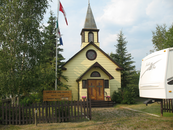
Gallery
Map and nearest places
| Longitude | Latitude |
|---|---|
| 63.5930555555556 | -135.895555555556 |
| 63°35'0"N | 135°53'0"W |
| Nearest places | ||
|---|---|---|
| Mayo Airport | 2.9km | |
| Carmacks Airport | 165.4km | |
| Dawson City Airport | 166.3km | |
| Carmacks | 168.4km | |
| Dawson City | 181.0km | |
| Faro | 199.2km | |
| Faro Airport | 200.0km | |
| Ross River | 250.4km | |
| Ross River Airport | 251.8km | |
| Beaver Creek Airport | 283.2km | |
| Beaver Creek | 285.8km | |
| Burwash Landing | 295.3km | |
| John Paul II International Airport | 7,198.2km | |
| Port Elizabeth Airport | 16,485.2km | |
Accomodation
Airports
Weblinks
Comments
You need to log in to add comment


