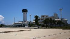
Gallery
Map and nearest places
| Longitude | Latitude |
|---|---|
| 24.8266666666667 | 125.144722222222 |
| 24°49'0"N | 125°8'0"E |
| Nearest places | ||
|---|---|---|
| Shimojishima | 1.3km | |
| Miyakojima Airport | 15.9km | |
| Miyakojima | 18.6km | |
| Tarama | 48.0km | |
| Tarama Airport | 51.2km | |
| Ishigaki | 100.5km | |
| Ishigaki Airport | 110.7km | |
| Hateruma Airport | 160.4km | |
| Hateruma | 161.7km | |
| Yonaguni | 219.9km | |
| Yonaguni Airport | 222.4km | |
| Kumejima Airport | 232.3km | |
| John Paul II International Airport | 8,933.9km | |
| Guarani International Airport | 19,945.2km | |
General informations
| Airport type | Regional airport |
| ICAO | RORS |
| IATA | SHI |
| Elevation | 54 ft / 16 m MSL |
| World Pax Ranking 2023 | #1108(+62) |
| World Pax Ranking 2022 | #1170(+37) |
| World Pax Ranking 2021 | #1207(+114) |
| World Pax Ranking 2020 | #1321(+340) |
| World Pax Ranking 2019 | #1661 |
| Year | Pax |
|---|---|
| 2024 | 470838 |
| 2023 | 424286 |
| 2022 | 319684 |
| 2021 | 203214 |
| 2020 | 115424 |
| 2019 | 126157 |
Weblinks
Comments
You need to log in to add comment


