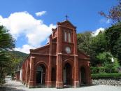
Gallery
Map and nearest places
| Longitude | Latitude |
|---|---|
| 32.7 | 128.833333333333 |
| 32°42'0"N | 128°49'0"E |
| Nearest places | ||
|---|---|---|
| Goto Airport | 3.8km | |
| Nagasaki Ojika Airport | 59.5km | |
| Ojika Island | 83.6km | |
| Nagasaki | 97.1km | |
| Nagasaki Airport | 103.8km | |
| Amakusa Airport | 126.5km | |
| Amakusa | 128.1km | |
| Iki Island | 145.8km | |
| Saga Airport | 145.9km | |
| Iki Airport | 146.5km | |
| Saga | 149.1km | |
| Tsushima | 171.9km | |
| John Paul II International Airport | 8,476.1km | |
| Rio Grande Airport | 19,898.8km | |
Airports
Weblinks
Comments
You need to log in to add comment


