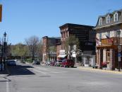
Gallery
Map and nearest places
| Longitude | Latitude |
|---|---|
| 44.333333 | -76.166667 |
| 44°19'0"N | 76°10'0"W |
| Nearest places | ||
|---|---|---|
| Gananoque Airport | 9.8km | |
| Clayton | 12.6km | |
| Alexandria Bay | 20.0km | |
| Kingston | 28.8km | |
| Kingston/Norman Rogers Airport | 36.3km | |
| Watertown International Airport | 39.7km | |
| Westport | 43.1km | |
| Watertown | 44.9km | |
| Brockville | 47.4km | |
| Brockville-Thousand Islands Regional Tackaberry Airport | 47.4km | |
| Ogdensburg International Airport | 67.8km | |
| Smiths Falls-Montague Airport | 70.4km | |
| John Paul II International Airport | 6,757.1km | |
| Busselton Regional Airport | 18,469.8km | |
Accomodation
Breweries
Airports
Weblinks
Comments
You need to log in to add comment


